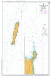
AUS 604 – Macquarie Island And Approaches on Sale
- Estimated Delivery : Up to 4 business days
- Free Shipping & Returns : On all orders over $200
This official Nautical Chart is produced by the Australian Hydrographic Office, and corrected fortnightly to Notice to Marines by Cairns Charts & Maps. This ensures it remains compliance with Safety of Navigation requirements. This marine chart, or sea map , is primarily produced to support the safe navigation of commercial shipping through Australian, Papua New Guinea and Solomon Island waters.
Nautical charts depict the seabed, or bathymetry, using a variety of colours to shade the depth regions. Darker blues indicate shallower water, while light blues and white indicate deeper water. A chart will also show continuous contour lines (at varying intervals depending on the scale of the chart), spot depths across the whole area, as well as different symbols indicating wrecks, shallow rocks and dangers, as well as details on lights, light houses, tides and currents.
For extensive detail on the symbology of nautical charts, the Symbols and Abbreviations used on Admiralty Charts is the definitive reference.
Bishop and Clerk Islets South East Reef South Reef Windsor Bay Hurd Point South East Bay South West Point Petrel Peak Green Point Caroline Cove Mount Haswell Lake Ainsworth Mount Ainsworth Caroline Point Carrick Bay Sodomy Ridge The Amphitheatre Cape Star Mount Kidson Waterfall Lake Whisky Creek Windy Ridge Mount Jeffryes Precarious Point Mount Stibbs Mount Fletcher Mount Aurora Lusitania Creek Lusitania Bay Raine Point Mount Hamilton Rockhopper Point Rockhopper Bay Lake Tiobunga Mount Martin Selkirk Creek Cape Toutcher Major Lake Mount Gwynn Sandell Bay Waterfall Bay Jessie Niccol Creek Davis Point Spaghetti Hill Varne Plateau Pyramid Lake Endeavour Lake Saddle Point Davis Bay Mount Blake Pyramid Peak Double Point Flynn Lake Cumberland Tarn Mount Waite Gratitude Lake Mount Law Sawyer Creek Green Gorge Sellick Bay Hell Bay Skua Lake Skua Tarn Mount Ifould Lake Ifould Betsey Tarn Green Gorge Tarn Soucek Bay Macquarie Island Lake Eitel Concord Lake Aurora Point Mount Eitel Midas Tarn Red River Aurora Cave Mount Harrisson Prion Lake Little Prion Lake Surry Lake Brothers Point Cormorant Point Flat Creek Tulloch Lake Mount Tulloch Duck Lagoon Stony Creek Square Lake Hatch Hill Penguin Walk Sandy Bay Finch Creek Mawson Point Bauer Bay Regalia Creek Gentoo Flat Douglas Point Boiler Rocks Emerald Lake Mount Blair Tussock Point Langdon Point Douglas Bay Mount Power Mount Elder Rookery Creek Langdon Bay Eagle Caves Island Lake Boot Hill The Nuggets Nuggets Creek Nuggets Point Middle Beach Floating Island Lake Eagle Point Unity Point Unity Bay Eagle Bay Scoble Lake North Mountain Halfway Hill Hidden Valley Elizabeth and Mary Point Half Moon Bay West Beach Hasselborough Corner Perseverance Bluff Buckles Bay Landing Beach The Isthmus First Gully Razorback Hill Gadget Gully Handspike Point Handspike Corner Lord Nelson Reef Aerial Cove Hut Hill Hasselborough Bay Cosray Rocks Catch Me Point Tottan Head Wireless Hill Garden Bay Goat Bay Lambing Gully Hayter Rock Tern Rock Secluded Beach Anchor Rock Gorilla Head Rock North Head Elliot Reef Judge and Clerk Islets Aurora Trough Hasselborough Ridge Caroline Trough Macquarie Trough Halfmoon Bay Selkirk Creek
| Title | Paper, Flat Paper, Laminated |
|---|
